SHOTSATTHEMOON
Mountain Gypsies - Cornwall (UK) to Nepal

ENERGIA (5120M), TAJIKISTAN
Summit: Mt Energia
Region: Fann Mountains, Tajikistan
Height: 5120m
Date: 21/08/17
Route: Normal Route
Grade: Russian 2B / 3A (PD+ / AD)
Approach and general information
The easiest place to start the route from is from the camp site Vertical Allaudin ($2 per person per night), which is some 4-5 hours’ drive from Dushanbe. You will need to arrange for private transport from Dushanbe as the last 2 hours of this is down an off-road track leading you into the centre of the Fann Mountains, a spectacular drive in itself.
There is a small café at the camp site but other than this there are no shops, no internet and no phone signal here, so make all necessary preparations before you leave Dushanbe. The closest place to get supplies otherwise is on the main road between Dushanbe and Ayni
Accommodation
There are various camping options along the route. If you don’t fancy paying to stay at the Vertical Allaudin camp site (I believe there also room/dorm options here) then there are a number of places you are able to pitch a tent next to the stunning Allaudin Lakes (30 minutes walk), where there is also a small café open intermittently. Both of these places are in stunning locations and well worth hanging around for a few days; there are ample trekking and rock climbing opportunities (mainly trad but some sport and some reasonable boulders at VA)
The Route
From Vertical Allaudin (circa 2600masl) cross the stream and follow a path up the valley for 30 minutes until you reach the Allaudin Lakes. The biggest of these lakes has a small café (hut) on the side as you approach. From here take the path around the right side of the lake and continue following the path up the valley to Mutnoe Lake (3500masl). Shortly after the main Allaudin lake, the path forks – take the left route.
Vertical Allaudin - Mutnoe Lakes; 3-4 hours.
There are camping spots at Mutnoe Lake and it’s not a bad option for the first night. Water in the lake is incredibly silty, but drinking water can be taken from the run off from the glacier, following the path around to the right of the lake.
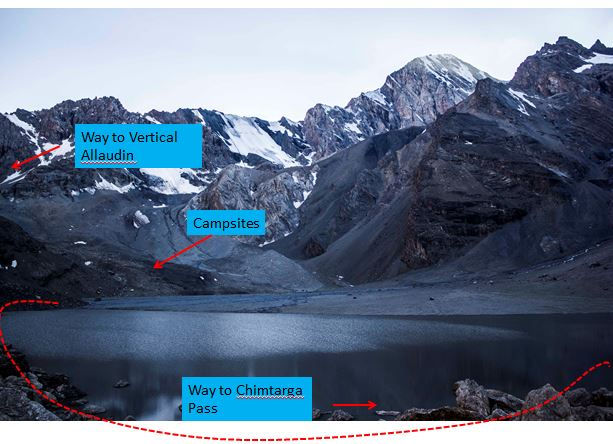
From here the route follows the same path around the right of Mutnoe Lake, passes the stream and takes you towards a moraine field and on to another glacier heading up towards Chimtarga Pass. Here the path starts to get fairly vague, but there are cairns that lead you up to the base of the glacier, where the path more-or-less completely disappears. Following the moraine field you soon find yourself on the glacier, although you might not realise it. Ascend the moraine keeping to the right, crossing a stream or two until, at about 4100m you reach a small area off the glacier with some camping spots (2-2.5 hours from Mutnoe Lake). From here the path, not leaving the glacier, becomes more obvious again and zig-zags up keeping right. It’s another 1-1.5hours to the higher camp at 4500m, 200m below Chimtarga Pass. This is a good place to use as a base camp for the summit.
From base camp to the pass (4750m) there is an obvious but strenuous path up the scree (40min), and here you will find more camping spots but it is a lot more exposed. From the pass follow a path left until you reach the base of the snow / ice leading to the summit. Earlier in the season may see snow cover by this point, but for us this was not until around 4850m.
The difficulty from here depends largely on the conditions; we had no snow coverage and were climbing on hard ice up to 45-50 degrees for around 200-220m (5 pitches). Ice screws were invaluable. If there is a good cover of consolidated snow then this would be pretty straight forward.
Nevertheless, keep to the left staying off the rocks until you get to a short rocky step just below the summit, there are a couple of in situ anchors for belay stations, but doubt these are maintained at all. From the top of the rock step it’s a hop, skip and a jump (not literally) to the summit, with magnificent views over the region.
Chimtarga Pass – Energia Summit: Completely dependent on conditions, took us around 4 hours.
On the descent it’s a fairly easy down-climb down the rock step but you may choose to rappel this, and there is an obvious anchor to do this from.
Essential gear
Boots, crampons, ice axe (2 axes would have been useful), rope etc., helmet, ice screws. Camping gear.
Maps and Guidebook
We struggled to find any remotely useful maps for the area on arrival in Tajikistan (we may have been looking in the wrong place) but there is some good information, albeit all in Russian, at Vertical Allaudin.
I would suggest trying to order maps online in advance of the trip.
Commercial trips
There are no mountain rescue services available in Tajikistan and the easiest and safest way to enjoy the Fann Mountains and bag some summits would be through a commercial trip, such as that offered by Remote Corner Adventures. Click here for more information.
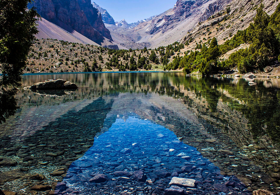
One of the stunning Allaudin Lakes
Mutneo Lake

Taking a rest en route to base camp

Basecamp looking towards Energia Summit

The summit of Energia from Chimtarga Pass. Stay on the right handside of the ridge, taking a direct line to the rock step at the top.
