


Bartang Valley Trek: A Walk into Wilderness
- Sep 14, 2017
- 4 min read
The Bartang Valley in the western Pamirs is a truly remote, wild expanse of land, stretching 400 kms east from the town of Rushon. It is striking in its vastness, overwhelming in its beauty. And to get there necessitates driving one of the worst roads known to man.
That we visited the valley at all was quite incidental. Lisa, Alex’s sister, was travelling with us at this point and we had arrived in the region with a week before she was due back in Dushanbe. The four-day trek to the Grumm-Grjimailo glacier was suggested to us by staff at the Pamirs Eco-Cultural Tourism Association in Khorog (10E.Davronov street, Central Park, Khorog | +992 93 442 55 55 | info@pecta.tj |open 08:00-18:00 every day). Though the maps available here were low res and small scale, they had produced a one-page flyer with basic details of this particular hike. The route is also marked on the app ‘maps.me’.
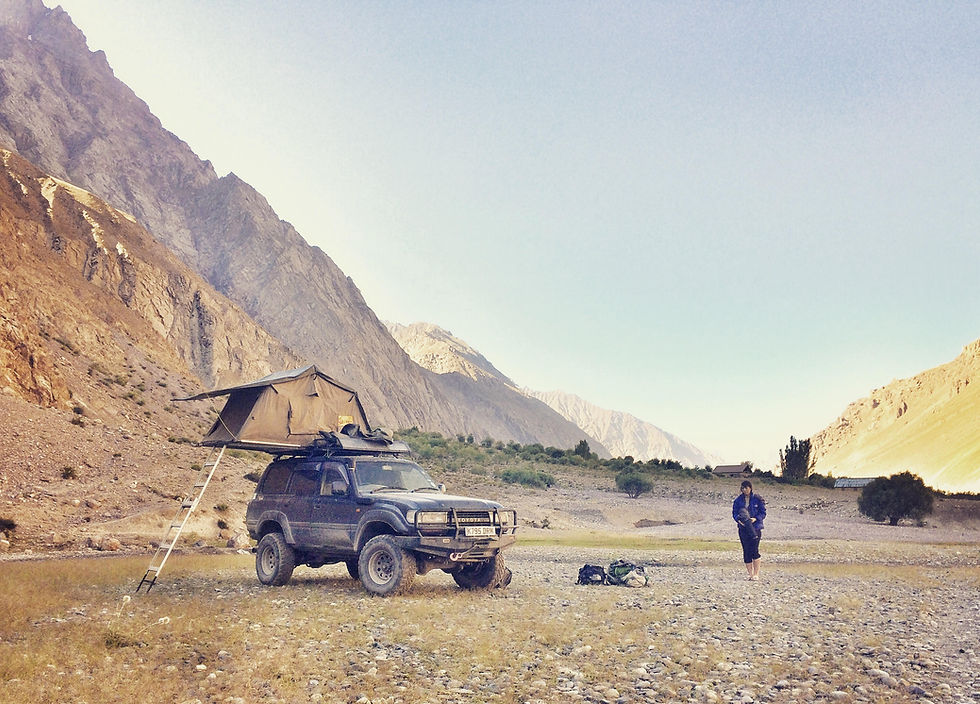
The trek starts from the charming hamlet of Pasor, a 135 mile drive from Khorog. For the first 65 kms of this journey the road is tarmac, albeit uneven, crumbling, and severely potted. On two occasions we got up to fifth gear, but on average we were in second. After this point (roughly 10 kms after the turn off into the valley at Rushon), you could be driving over anything from sand, gravel or boulders, to bridges rickety enough to turn the most ardent atheist pious. We spent a considerable portion of this section in low gear ratio and were profoundly relieved to be in such a sturdy 4x4. In total the journey took us around 10 hours, which we split over two days, camping just outside the hamlet of Darjomj – one of the few places the road passes through a plateau.
Day 1
We reach Pasor (2992m above sea level) in the early afternoon and are immediately invited into a home for ‘tea’, which – typically, we are learning, in this part of the world – actually equates to a full meal. Over bread and tinned fish, Dan and Lisa decide to hire a donkey for their baggage and a price of $20 a day is agreed. Ali, a gentle local with basic English and owner of said donkey, will accompany us (his fee, it seems, is included in the beast’s), and we finally set off around 3pm.
Though not physically challenging, it should be noted that this trek features a couple of river crossings. Typically, these entailed wading barefoot through knee-deep icy cold water. I can’t say this was an enjoyable experience for us, but the donkey seemed to oppose it with every bone in his body (never again shall I use the phrase ‘stubborn as a mule’ lightly!)


Two hours, and a great deal of brute force later, we have progressed 3.5kms up the valley and make camp for the night.
Day 2
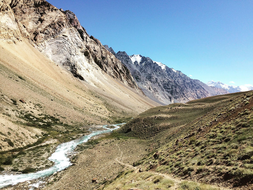
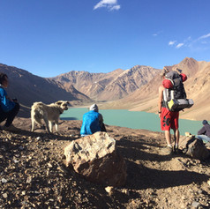
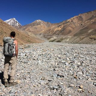
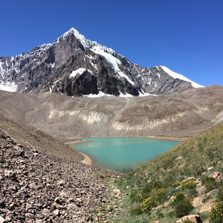
To make up for yesterday’s poor performance and reach or intended second camp, we cover a distance of 20km and ascend over 1000m today. With another couple of river crossings, and a large section of moraine to scramble over, this is tough going. It is, however, impossible to feel sorry for yourself for long when the landscape is this impressive. Other than the path in front of us, which at most resembles a cattle track, there is not a man-made structure to be seen for as far as the eye can see (and in the Bartang, the eye can see pretty damn far). As we progress up the valley we pass a series of turquoise lakes, leading eventually to the larger ‘Khafraz Lake’ (4024m), next to which we make our camp.


Day 3
Our intention today had been to reach the ‘end’ of the trail: a viewpoint over the Grumm-Grjimailo glacier. However, as we were starting to struggle with the altitude, we turned back a kilometre or so short of this. Whilst on one level this was an obvious disappointment, the views we already had across snow-capped peaks were more than enough to satisfy.


Our distance still totalled 17km and we reached an altitude of 4500m. The route again passed across a lot of moraine and at times was difficult to navigate. There were cairns, but they were few and far between. Half was through we passed another small lake, alongside which it would have been possible to camp. Were we to do the trek again, I would suggest adding another day for acclimatisation and camping the third night here.
Day 4
We walk the 24km back to Pasor, and arrive fairly exhausted in the early evening. Ali’s family invite us for a hearty dinner and sleep soundly camped in the hamlet.
Notes on trek
We completed this trek from 16-19 August. Whilst it was warm in the day, the temperatures dropped quite low at night (below freezing at our second camp), and therefore a appropriate equipment is recommended.
There were several sources of drinking water along the way but these were not always immediately apparent. Thankfully, Ali was able to point these out to us but without him I suspect we may have resorted to filtering and boiling river water at times.
Ali’s family did not even remotely hint that they expected anything in return for the two meals they served us. However, having read that local currency should tentatively be offered in such situations, the small amount of money we gave them was gratefully received.
The Bartang Valley really is remote. After the turn off at Rushon there are no fuel stations, and only a couple of small, unmarked 'shops'. We suggest purchasing all of your supplies before leaving Khorog.
Other than a solitary shepherd, we did not see another human being for the duration of this trek. Therefore, I would recommend bringing a full first aid kit with you in case of accident.
For professional organised trips to Tajikistan visit Remote Corner Adventures.
Comments